- Screen Reader Access
- Skip to : main content / navigation
-
- Text Size
- Home
- Sitemap
- Contact us
- हिंदी


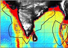
India, a traditionally maritime country, has effectively participated in all the deliberationsUNCLOS and enacted comprehensive legislations to regulate the maritime activities in its ocean waters. The 7516 km long coastline (including the coastline of Andaman and Nicobar Islands and Lakshadweep Islands) bestow upon India with an EEZ of in area, which is the 12th largest EEZ in the world.
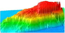
Realizing the need to be cognizant about India’s Exclusive Economic Zone (EEZ) of nearly 23,72,298 sq. km for an optimum utilization of the resources available in the oceanic region and to enhance our knowledge about the scientific issues related to the oceans around us, the Government of India sanctioned the project on comprehensive mapping of the EEZ of India. The Ministry of Earth Sciences (MoES) has entrusted the responsibility of organizing and implementing the project with the National Centre for Polar & Ocean Research (NCPOR) as the nodal organization, while the National Institute of Ocean Technology (NIOT) and the National Institute of Oceanography (NIO) have been identified as participating organizations in the project. State-of–the-art multi-beam swath bathymetric surveying of the EEZ is planned to be conducted under this national project, apart from gathering all other possible marine geophysical data..
The project is being implemented in two phases:
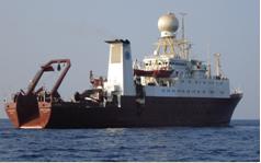
Phase I : Deep waters - beyond 500 m depth using vessels ORV Sagar Kanya, TDV Sagar Nidhi & other chartered vessels
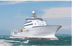
Phase II : Shallow waters- (10-500 m) using vessels TDV Sagar Nidhi, Sagar Shukti, Sagar Purvi & Sagar Paschimi
Datasets being generated:
|
Sl. No. |
Data Type |
|---|---|
| 1 | Multibeam Bathymetry |
| 2 | Multibeam backscatter |
| 3 | Single Beam Bathymetry |
| 4 | SVP / CTD data |
| 5 | Surface Sound Velocity (SSV) profiles |
| 6 | Sub-bottom Profiler (SBP) data |
| 7 | Magnetic & gravity data |
| 8 | Sediment cores |
 |
 |
 |
 |
 |
 |

